At a glance
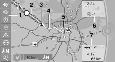
1 Function bar
2 Route section with traffic obstruction
3 Traffic sign for traffic obstruction
4 Planned route
5 Current location
6 Upper status field
7 Lower status field
Lines in the map
Streets and routes are displayed in different colors and styles depending on their classification. Dashed lines represent railways and ferry connections. Country borders are indicated by thin lines.
Traffic obstructions
Small triangles along the planned route indicate route sections with traffic obstructions, depending on the map scale. The direction of the triangles indicates the direction of the obstruction.
The traffic signs indicate the significance of the obstruction.
- Red traffic sign: the obstruction affects the planned route or direction.
- Gray traffic sign: the obstruction does not affect the planned route or direction.
Traffic bulletins.
Planned route
After destination guidance is started, the planned route is displayed on the map.
Status fields
Show/hide: press the controller.
- Upper status field: time, telephone, and entertainment details.
- Lower status field: symbol for active destination guidance, status of traffic bulletins, time of arrival, and distance to destination.
Function bar
The following functions are available in the function bar:
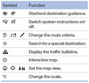
To change to the function bar, move the controller to the left.
See also:
Selecting chassis and suspension tuning
Selecting chassis and suspension tuning
Press the button.
The system switches between the two chassis
and suspension tuning settings.
▷ Sport:
The LED in the button lights up and SPORT
...
Roadside Assistance
At a glanceBMW Roadside Assistancecan be contacted if assistance is needed in the
event of a breakdown.
Contact with BMW Roadside Assistancecan also be established using a Check
Control message.
...
General information
▷ Instructions for voice activation system
▷ When making a destination entry by voice,
you can change between voice operation
and iDrive.
▷ To have the available spoken instruc ...