Destination entry by map
Selecting the destination
1. "Navigation"
2. "Map"
The current position of the vehicle is indicated
on the map.
3.  "Interactive map"
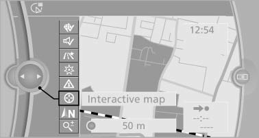
4. Select the destination with crosshairs.
- To change the scale: turn the controller.
- To shift the map: move the controller in the required direction.
- To shift the map diagonally: move the controller in the required direction and turn it.
Specifying the street
If the system does not recognize a street, one of the following is displayed:
- The name of a street in the vicinity.
- The county.
- The coordinates of the destination.
Additional functions
Additional functions are available on the interactive map after the controller is pressed.
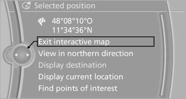
 Select the symbol.
"Start guidance" or "Add as another destination" Add a destination as a further destination.- "Exit interactive map": return to the map view.
- "View in northern direction" or "View in driving direction"
- "Display destination": the map section around the destination is displayed.
- "Display current location": the map section around your current location is displayed.
- "Find points of interest": the search for special destinations is started.
See also:
Washer/wiper system
Do not switch on the wipers if frozen<>
Do not switch on the wipers if they are frozen
onto the windshield; otherwise, the wiper
blades and the windshield wiper motor may be
damaged.&# ...
Storing favorites
Up to 30 favorites can be stored in the favorites
list. Available favorites are artist, track, game,
league, and team.
Storing the artist, track, or game
It is only possible to store favorites t ...
Address book
Selecting a destination from the
address book
1. "Navigation"
2. "Address book"
Contacts with addresses are displayed if
these have been checked as destinations
from among th ...