Destination entry by map
Selecting the destination
1. "Navigation"
2. "Map"
The current position of the vehicle is indicated
on the map.
3.  "Interactive map"
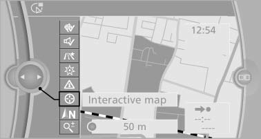
4. Select the destination with crosshairs.
- To change the scale: turn the controller.
- To shift the map: move the controller in the required direction.
- To shift the map diagonally: move the controller in the required direction and turn it.
Specifying the street
If the system does not recognize a street, one of the following is displayed:
- The name of a street in the vicinity.
- The county.
- The coordinates of the destination.
Additional functions
Additional functions are available on the interactive map after the controller is pressed.
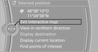
 Select the symbol.
"Start guidance" or "Add as another destination" Add a destination as a further destination.- "Exit interactive map": return to the map view.
- "View in northern direction" or "View in driving direction"
- "Display destination": the map section around the destination is displayed.
- "Display current location": the map section around your current location is displayed.
- "Find points of interest": the search for special destinations is started.
See also:
Interior motion sensor
The windows and glass sunroof must be closed
for the system to function properly. ...
Modern Line
In contrast to Luxury Line models, the high-class trim elements included in
Modern Line versions of the new BMW 3-Series Sedan are all in satinated
aluminium, underlining the contemporary characte ...
Break-in period
Moving parts need breaking-in time to adjust to each other. Please follow the
instructions below in order to achieve the optimal service life and economy of operation
for your vehicle.
Engine and ...