Traffic bulletins
Overview
> You can display the traffic bulletins from radio stations that broadcast the
TMC (Traffic Message Channel) of a traffic information service. Bulletins about
traffic obstructions and hazards are continuously updated.
> Traffic bulletins are indicated by symbols on the map.
> Traffic bulletins for the surrounding area are stored in a list.
 The symbol in the toolbar of the map view turns
red if a traffic bulletin relates to the calculated route.
The symbol in the toolbar of the map view turns
red if a traffic bulletin relates to the calculated route.
Certain BMW models equipped with navigation have the capability to display real-time traffic information. If your system has this capability the following additional terms and conditions apply:
An End-User shall no longer have the right to use the Traffic Data in the event that the EndUser is in material breach of the terms and conditions contained herein.
A. Total Traffic Network, a division of Clear Channel Broadcasting, Inc. ("Total Traffic Network") holds the rights to the traffic incident data and RDS-TMC network through which it is delivered. You may not modify, copy, scan or use any other method to reproduce, duplicate, republish, transmit or distribute in any way any portion of traffic incident data. You agree to indemnify, defend and hold harmless BMW of North America, LLC. ("BMW NA") and Total Traffic Network, Inrix, Inc (and their affiliates) against any and all claims, damages, costs or other expenses that arise directly or indirectly out of (a) your unauthorized use of the traffic incident data or the RDS-TMC network, (b) your violation of this directive and/or (c) any unauthorized or unlawful activities by you in connection herewith.
B. Total Traffic Network traffic data is informational only. User assumes all risk of use. Total Traffic Network, BMW NA, and their suppliers make no representations about content, traffic and road conditions, route usability, or speed.
C. The licensed material is provided to license "as is," and "where is". Total Traffic Network, including, but not limited to, any and all third party providers of any of the licensed material, expressly disclaims, to the fullest extent permitted by law, all warranties or representations with respect to the licensed material (including, without limitation, that the licensed material will be error-free, will operate without interruption or that the traffic data will be accurate), express, implied or statutory, including, without limitation, the implied warranties of merchantability, non-infringement fitness for a particular purpose, or those arising from a course of dealing or usage of trade.
D. Neither Total Traffic Network, Inrix, Inc. nor BMW NA will be liable to you for any indirect, special, consequential, exemplary, or incidental damages (including, without limitation, lost revenues, anticipated revenues, or profits relating to the same) arising from any claim relating directly or indirectly to use of the traffic data, and even if Total Traffic Network, Inrix, Inc., or BMW NA are aware of the possibility of such damages. These limitations apply to all claims, including, without limitation, claims in contract and tort (such as negligence, product liability and strict liability). Some states do not allow the exclusion or limitation of incidental or consequential damages, so those particular limitations may not apply to you.
Activating/deactivating reception1. "Navigation"
2. Open "Options".
3. "Receive Traffic Info"
1. "Navigation"
2. "Map"
3.  "Traffic Info"
First, the traffic bulletins for the calculated route are displayed.
The traffic bulletins are sorted in the order of their distance from the current vehicle position.
4. Select a traffic bulletin.
 "More information":
Display additional information.
5. Scroll to the next or previous traffic bulletin if desired.
Traffic bulletins on the map"Traffic conditions/gray map" active: the Control Display changes to a grayscale display. This enables a better view of the traffic bulletins. The day/night mode is disregarded in this setting. Symbols or special destinations are no longer displayed.
1. "Navigation"
2. "Map"
3. Open "Options".
4. "Settings"
5. "Traffic conditions/gray map"
Symbols in the map view
Depending on the scale of the map and the location of the traffic obstruction along the route, the symbols for the traffic obstructions are displayed.
Additional information in the map viewDepending on the map scale, a traffic obstruction's length, direction and impact are displayed on the map using triangles or gray bars along the calculated route.
> Red: traffic congestion
> Orange: stop-and-go traffic
> Yellow: heavy traffic
> Green: clear roads
> Gray: general traffic information, e.g. construction zone
The bulletins displayed depend in the respective traffic information service.
Filtering traffic bulletinsSet which traffic bulletins are displayed on the map.
1. "Navigation"
2. "Map"
3. Open "Options".
4. "Traffic Info categories"
5. Select the desired categories.
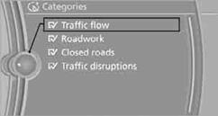
Traffic bulletins from the selected categories are displayed on the map.
> Traffic bulletins that lie on the route are always shown.
> For your personal safety, it is not possible to hide traffic bulletins that announce
a potential hazard.
Semi-dynamic route guidance
With traffic bulletin reception switched on, semi-dynamic route guidance is active.
The system takes into account the existing traffic bulletins during route guidance. A message is displayed as a function of the route, the traffic bulletins, and the possible alternate routes. The message displays the traffic bulletin and in the event of a traffic obstruction, suggests an alternate route. The difference in distance and time between the original route and the alternate route are also displayed.
Taking an alternate route:  "Detour"
With particular hazards, e.g. objects on the roadway, a message is displayed without a possible alternate route.
It is also possible to take alternate routes can also be taken if the traffic reports are accessed via the list:
1. "Navigation"
2. "Map"
3. "Traffic Info"
4. "Detour information"
5. "Detour"
Dynamic destination guidance
The route is automatically changed in the event of traffic obstructions.
> The system does not point out traffic obstructions along the original route.
> Traffic bulletins will continue to be displayed on the map.
> Depending on the type of road and the nature and length of the traffic obstruction, the route can also be calculated so that you travel through the traffic obstruction.
> Certain hazards are displayed regardless of the setting.
To activate dynamic route guidance:
1. "Navigation"
2. Open "Options".
3. "Dynamic guidance"
See also:
Tow-starting
Note
Do not tow-start your vehicle.
Due to the automatic transmission, the engine
cannot be started by tow-starting.
Have the cause of the starting difficulties remedied. ...
The concept
DSC prevents traction loss in the driving wheels
when driving away and accelerating.
DSC also recognizes unstable vehicle conditions,
such as fishtailing or nose-diving. Subject
to physical lim ...
Rear seat heating
Switching on
Press the button once for each
temperature
level.
The maximum temperature is reached when
three LEDs are lit.
Switching off
Press the button longer.
The LEDs go out.
Temper ...