At a glance
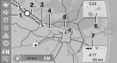
1. Function bar
2. Route section with traffic obstruction
3. Traffic sign for traffic obstruction
4. Planned route
5. Current location
6. Upper status field
7. Lower status field
Lines in the map
Streets and routes are displayed in different colors and styles depending on their classification.
Dashed lines represent railways and ferry connections.
Country borders are indicated by thin lines.
Traffic obstructions
Small triangles along the planned route indicate route sections with traffic obstructions, depending on the map scale. The direction of the triangles indicates the direction of the obstruction.
The traffic signs indicate the significance of the obstruction.
▷ Red traffic sign: the obstruction affects the
planned route or direction.
▷ Gray traffic sign: the obstruction does not
affect the planned route or direction.
Traffic bulletins
Planned route
After destination guidance is started, the planned route is displayed on the map.
Status fields
Show/hide: press the controller.
▷ Upper status field: time, telephone, and entertainment
details.
▷ Lower status field: symbol for active destination
guidance, status of traffic bulletins,
time of arrival, and distance to destination.
Function bar
The following functions are available in the function bar:
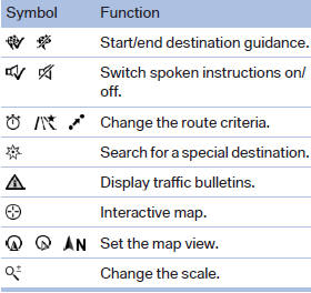
To change to the function bar, move the controller to the left.
See also:
Destination entry by voice
General information
► Instructions for voice activation system, refer
to page 22.
► When making a destination entry by voice,
you can change between voice operation
and iDrive.
υ ...
Camera
The camera is located on the front of the interior
rearview mirror.
Keep the area in front of the interior rearview
mirror clear. ...
Filtering the message list
The message list can be filtered when more than
one type of message exists.
1. "Filter:"
2. Select the type of message.
▷ "All"
All messages are displayed.
▷ & ...