Destination entry by map
Selecting the destination
1. "Navigation"
2. "Map"
The current position of the vehicle is indicated on the map.
3.  "Interactive map"
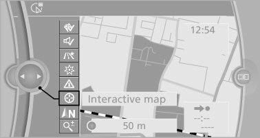
4. Select the destination with crosshairs.
► To change the scale: turn the controller.
► To shift the map: move the controller in
the required direction.
► To shift the map diagonally: move the
controller in the required direction and
turn it.
Specifying the street
If the system does not recognize a street, one of the following is displayed:
► The name of a street nearby.
► The county.
► The coordinates of the destination.
Additional functions
Additional functions are available on the interactive map after the controller is pressed.
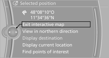
►  Select the symbol.
"Start guidance" or "Add as another
destination"
► "Exit interactive map": return to the map
view.
► "View in northern direction" or "View in
driving direction"
► "Display destination": the map section
around the destination is displayed.
► "Display current location": the map section
around your current location is displayed.
► "Find points of interest": the search for special
destinations is started.
See also:
Communication
All of the options available to you for mobile
communication with family, friends, business
partners, and service providers are described in
this chapter. ...
Easy to operate iDrive
Then there's the iDrive.
After testing a series of BMW's this year, I am starting to take a more
German approach to the iDrive. Americans are just stupid.
Please don't be offended by that if you ...
Vehicle equipment
All standard, country-specific and optional
equipment that is offered in the model series is
described in this chapter. Therefore, equipment
is also described that is not available in a vehicle, ...