At a glance
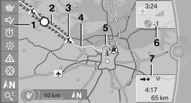
1. Function bar
2. Route section with traffic obstruction
3. Traffic sign for traffic obstruction
4. Planned route
5. Current location
6. Upper status field
7. Lower status field
Lines in the map
Streets and routes are displayed in different colors and styles depending on their classification.
Dashed lines represent railways and ferry connections.
Country borders are indicated by thin lines.
Traffic obstructions
Small triangles along the planned route indicate route sections with traffic obstructions, depending on the map scale. The direction of the triangles indicates the direction of the obstruction.
The traffic signs indicate the significance of the obstruction.
▷ Red traffic sign: the obstruction affects the
planned route or direction.
▷ Gray traffic sign: the obstruction does not
affect the planned route or direction.
Traffic bulletins
Planned route
After destination guidance is started, the planned route is displayed on the map.
Status fields
Show/hide: press the controller.
▷ Upper status field: time, telephone, and entertainment
details.
▷ Lower status field: symbol for active destination
guidance, status of traffic bulletins,
time of arrival, and distance to destination.
Function bar
The following functions are available in the function bar:
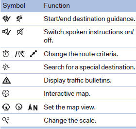
To change to the function bar, move the controller to the left.
See also:
Aerodynamic optimisation of underside panelling
As the excellent drag coefficient (cd = 0.26) would suggest, the aerodynamics
of the new BMW 3-Series have been intensively honed in a state-of-the-art wind
tunnel. The optimised aerodynamics also ...
Image on the Control Display
The traffic area to the left and right is displayed
on the Control Display.
Image on the Control Display
Guidelines at the bottom of the image show the
position of the front of the vehicle.
B ...
Before mounting
If the rear seat backrests are adjustable:
Before mounting child restraint fixing systems,
return all of the rear seat backrests to the basic
position. ...