
Destination entry by map
Selecting the destination
1. "Navigation"
2. "Map"
The current position of the vehicle is indicated
on the map.
3.  "Interactive map"
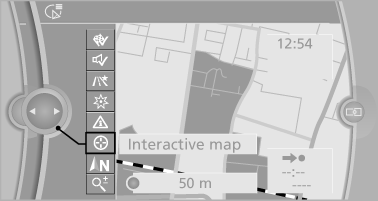
4. Select the destination with crosshairs.
▷ To change the scale: turn the controller.
▷ To shift the map: move the controller in the required direction.
▷ To shift the map diagonally: move the controller in the required direction and turn it.
Specifying the street
If the system does not recognize a street, one of the following is displayed:
▷ The name of a street nearby.
▷ The county.
▷ The coordinates of the destination.
Additional functions
Additional functions are available on the interactive map after the controller is pressed.
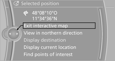
▷  Select the symbol.
"Start guidance" or "Add as another destination".
▷ "Exit interactive map": return to the map view.
▷ "View in northern direction" or "View in driving direction".
▷ "Display destination": the map section around the destination is displayed.
▷ "Display current location": the map section around your current location is displayed.
▷ "Find points of interest": the search for special destinations is started.
See also:
Destination entry
In entering your destination you can select from the following options:
> Entering a destination manually, see below
> Selecting destination from address book,
> Last destinations,
> S ...
Automatic deactivation during forward travel
The system switches off when a certain driving
distance or speed is exceeded.
Switch the system back on if necessary. ...
Using contact data
At a glance
Contact data from calendar entries, appointments,
tasks, emails and notes can be stored or
selected*.
Displaying contact or selecting phone
number
1.
"Use contact data&qu ...