Destination entry by map
Selecting the destination
1. "Navigation"
2. "Map"
The current position of the vehicle is indicated on the map.
3.  "Interactive map"
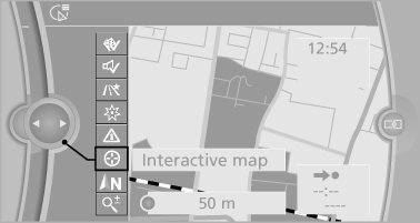
4. Select the destination with crosshairs.
► To change the scale: turn the controller.
► To shift the map: move the controller in
the required direction.
► To shift the map diagonally: move the
controller in the required direction and
turn it.
Specifying the street
If the system does not recognize a street, one of the following is displayed:
► The name of a street nearby.
► The county.
► The coordinates of the destination.
Additional functions
Additional functions are available on the interactive map after the controller is pressed.
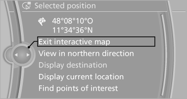
►  Select the symbol.
"Start guidance" or "Add as another
destination"
► "Exit interactive map": return to the map
view.
► "View in northern direction" or "View in
driving direction"
► "Display destination": the map section
around the destination is displayed.
► "Display current location": the map section
around your current location is displayed.
► "Find points of interest": the search for special
destinations is started.
See also:
Date
The settings are stored for the remote control currently in use, refer also to
Personal Profile on page 28.
Setting the dateIn the instrument cluster
To set the dd/mm or mm/dd date format, refer t ...
Switching on wipers
Press the wiper lever upward, arrow 1.
The lever automatically returns to its initial position
when released.
Normal wiper speed
Press up once.
The system switches to operation in the intermitte ...
What to do if...
Information on suitable mobile phones.
Appointments, tasks, notes, text messages, or
e-mails from the mobile phone are not displayed.
The mobile phone is not capable of the
missing function ...