Destination entry by map
Selecting the destination
1. "Navigation"
2. "Map"
The current position of the vehicle is indicated
on the map.
3.  "Interactive map"
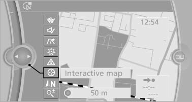
4. Select the destination with crosshairs.
- To change the scale: turn the controller.
- To shift the map: move the controller in the required direction.
- To shift the map diagonally: move the controller in the required direction and turn it.
Specifying the street
If the system does not recognize a street, one of the following is displayed:
- The name of a street in the vicinity.
- The county.
- The coordinates of the destination.
Additional functions
Additional functions are available on the interactive map after the controller is pressed.
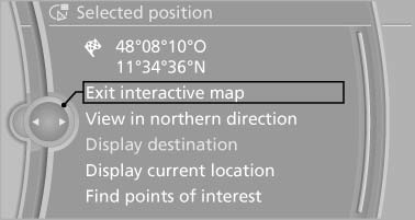
 Select the symbol.
"Start guidance" or "Add as another destination" Add a destination as a further destination.- "Exit interactive map": return to the map view.
- "View in northern direction" or "View in driving direction"
- "Display destination": the map section around the destination is displayed.
- "Display current location": the map section around your current location is displayed.
- "Find points of interest": the search for special destinations is started.
See also:
Adjusting
Vehicle
Equipment
...
Following the initial pairing
▷ The mobile phone is detected/connected in
the vehicle within a short period of time
when the engine is running or the ignition is
switched on.
▷ The phone book entries of the tele ...
Safety
Standard safety features include antilock brakes, an electronic stability
system, side-impact airbags for the front seats, side curtain airbags for both
rows, and active front head restraints.
F ...