Destination entry by map
Selecting the destination
1. "Navigation"
2. "Map"
The current position of the vehicle is indicated on the map.
3.  "Interactive map"
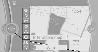
4. Select the destination with crosshairs.
► To change the scale: turn the controller.
► To shift the map: move the controller in
the required direction.
► To shift the map diagonally: move the
controller in the required direction and
turn it.
Specifying the street
If the system does not recognize a street, one of the following is displayed:
► The name of a street nearby.
► The county.
► The coordinates of the destination.
Additional functions
Additional functions are available on the interactive map after the controller is pressed.
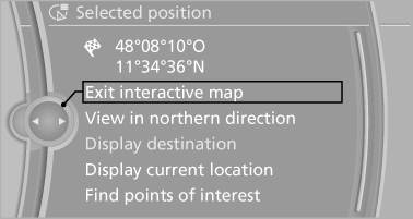
►  Select the symbol.
"Start guidance" or "Add as another
destination"
► "Exit interactive map": return to the map
view.
► "View in northern direction" or "View in
driving direction"
► "Display destination": the map section
around the destination is displayed.
► "Display current location": the map section
around your current location is displayed.
► "Find points of interest": the search for special
destinations is started.
See also:
Storing
1. Switch on the ignition.
2. Set the desired position.
3. Press the button. The LED in
the
button lights up.
4. Press the desired button 1 or 2. The LED
goes out.
If the M button is presse ...
Video playback
OverviewVideo playback possible via snap-in adapter. They can be operated via iDrive.
Sound is output over the vehicle speakers.
PlaybackFor your own safety, the video image is only displayed up to ...
Front seat heating
Switching on
Press the button once for each
temperature
level.
The maximum temperature is reached when
three LEDs are lit.
If the drive is continued within approx. 15 minutes,
the seat h ...